 Home: ForBestAdvice
- Real
Estate - Natural
Gas Pipeline Maps - California - Santa
Clara - Palo Alto,
Stanford & Mtn View Home: ForBestAdvice
- Real
Estate - Natural
Gas Pipeline Maps - California - Santa
Clara - Palo Alto,
Stanford & Mtn View
|
||
 |
Natural Gas
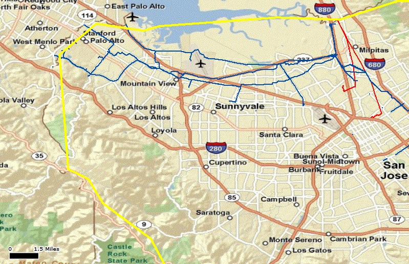
Pipeline Maps Palo Alto, Stanford & Mountain View Santa Clara County - California - CA |
 |
|
|
||
|
|
||
|
Map Source:
Our maps were created using the Department of Transportation (DOT)
Pipeline and Hazardous Materials Safety Administration PHMSA public map
viewer than taking screen shots to post them
here.
On September 9, 2010 a 30-inch diameter natural gas transmission pipeline (Line 132) owned and operated by Pacific Gas & Electric Company (PG&E) ruptured in a residential area in San Bruno, California. The explosion and fire killed 8 people, destroyed 37 homes and damaged another 18 homes in the blast vicinity. Before and After Photos We would not want to own a home within the blast zone at any price and would try to avoid homes close to the pipeline that are at risk of destruction from a fire. Natural Gas Pipeline Map for Palo Alto, Stanford & Mountain View:
|
||||||
|
|
||||||
|
 |